
Navigating Beyond Pixels: The Ancient Roots of Wayfinding
In an age of blue-dot navigation and instant GPS directions, we've forgotten something profound: humans were once extraordinary navigators, with skills that went far beyond technological convenience.
Jump to:
Inuit Snow and Ice Mapping
The Lost Art of Wayfinding
Imagine finding your way across thousands of miles using nothing but the stars, wind patterns, and generational knowledge passed down through stories. Long before smartphones, humans developed navigation systems so intricate and sophisticated that they challenge our modern understanding of geographical intelligence. Today, we've traded this profound connection to landscape for algorithmic convenience, transforming navigation from an intuitive, wonder-filled exploration into a passive consumption of digital instructions.
Our technological dependency has systematically eroded spatial awareness across every domain. Urban residents now rely on ride-sharing apps instead of understanding city layouts, children's explorations are confined by parental tracking technologies, and wilderness adventurers prioritize pre-downloaded trail routes over genuine discovery. Where previous generations developed spatial reasoning through physical exploration—reading sun positions, traversing terrains, getting intentionally and unintentionally lost—we now outsource navigation to algorithms that reduce landscapes to mere backdrops for digital consumption. We've transformed from active navigators to passive recipients, trading the rich, multisensory experience of wayfinding for the sterile efficiency of a blue digital dot.Indigenous Navigation: A Global Wisdom
Our journey begins with the remarkable wayfinding methods developed by indigenous cultures around the world—techniques that reveal navigation as an art form, a spiritual practice, and a deep conversation with landscape.
Polynesian Celestial Navigation
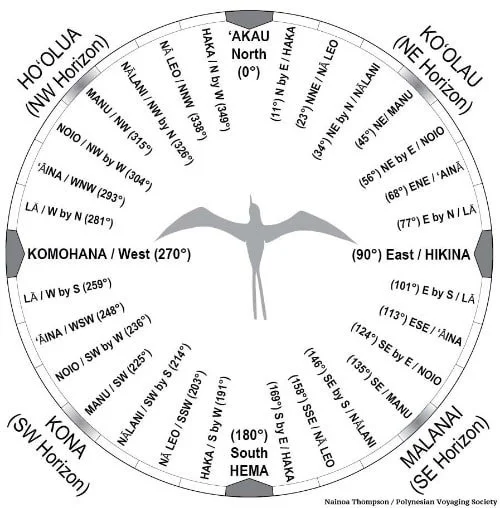
In the vast Pacific Ocean, Polynesian navigators became legendary for their ability to traverse thousands of miles of open water using nothing more than celestial observations. These master mariners would:
Memorize hundreds of star positions
Track how celestial bodies moved across different seasons
Read subtle changes in wave patterns
Interpret wind currents
Understand cloud formations as navigational markers
A single voyage might span thousands of miles, guided by nothing more than mathematical understanding of the night sky and generations of accumulated knowledge.
Inuit Snow and Ice Mapping
In the Arctic's unforgiving landscape, Inuit people developed a navigation system that would seem like magic to modern technological minds. Their survival depended on reading:
Subtle variations in snow crystals
Wind-created snow formations
Microscopic changes in ice thickness
Barely perceptible color variations in snow and landscape
Where we might see a uniform white expanse, Inuit navigators saw a complex, information-rich environment telling detailed stories about direction, safety, and possible routes. Read More here.
Aboriginal Songlines: Mapping Consciousness and Country
Perhaps the most extraordinary navigation system comes from Aboriginal Australian culture: the Songlines. These are not merely geographical instructions, but complex narrative networks that interweave landscape, spirituality, cultural knowledge, and survival.
Imagine a map that isn't drawn on paper, but sung into existence. Songlines are oral geographic archives describing the journeys of ancestral spirits during the Dreamtime—a foundational creation period in Aboriginal cosmology.
A single songline might stretch hundreds of kilometers, passing through multiple language groups' traditional lands. Travelers would know exactly where they were by reciting specific song sections containing precise environmental descriptions: the curve of a riverbank, the shape of a rock formation, the flowering of a particular plant.
These songs were living repositories of:
- Ecological knowledge
- Astronomical observations
- Tribal histories
- Spiritual beliefs
- Survival techniques
- Genealogical records

Beyond Navigation: A Holistic Worldview
What makes these navigation methods revolutionary is their rejection of geography as a static, two-dimensional representation. For these cultures, navigation was an act of:
- Storytelling
- Cultural preservation
- Spiritual connection
- Environmental dialogue
The Technological Paradox
Our modern GPS technologies, while remarkable, have inadvertently diminished our spatial intelligence. The constant digital affirmation of our location has eroded the human capacity to read environmental cues, from the angle of the sun to the subtle shifts in urban architecture. Our ancestors could detect the proximity of water by observing bird patterns and plant life; now we rely on blue dots to find the nearest coffee shop. The convenience of immediate positioning has stripped away the layered richness of gradual geographical discovery that once connected us to our surroundings.
By always knowing exactly where we are, we've forgotten the magic of getting wonderfully, curiously lost.
An Invitation to Rediscover
As we explore these ancient navigation methods, I invite you to consider: What might we learn by reconnecting with these deeper, more holistic ways of understanding our environment?
In our next installment, we'll dive deeper into the intimate language of maps and explore how cartography is far more than lines on paper.
Stay curious. Stay navigating.