
The True Stars of Cartography: Ottoman Mapmakers

Soil, Plants and Basalt, Abdurrahim Hilmi Bey, fig. 1
The Ottoman Empire’s made priceless contributions to the world, from medical instruments, to architecture, and even mathematics, it’s no wonder whole degrees are offered in studying their bottomless contributions to society. Presently, my interest is honed in on their Cartographical contributions. Through examining the maps that were produced just before, during, and following the collapse of this nearly 600 year old World Power, we expose ourselves to the nuanced lives that experienced some of the most tumultuous moments in modern history. In this article, we’ll briefly explore the work of three Arab Cartographers: Osman Nuri, Abdurrahim Hilmi Bey, and Ikbal Kutuphanesi Sahibi Huseyin.
The Empire was defeated in World World I in 1918. They’d chosen the wrong side during the war and now had to partition its territory and sign treaties. The Ottoman Sultanate was abolished by the Turkish Grand National Assembly in Ankara on November 1, 1922. It’s sobering to realize that such a pivotal part of Human History can fold in on itself in such a seemingly short period of time (the earthquake of War). As I deepen in my explorations of cartography, ethnography, and cosmography, the work of Hilmi Bey, Huseyin, and Nuri are both educational on how the field of cartography reasoned with Global calamity and are visually poetic, showcasing a hopefulness that withstood the test of time. There isn’t much info on their lives, but we can know them through their work, their journals, and dedication to organizing the world around them.

The Balkans 1909, Osman Nuri, fig. 2
Tending the Gash
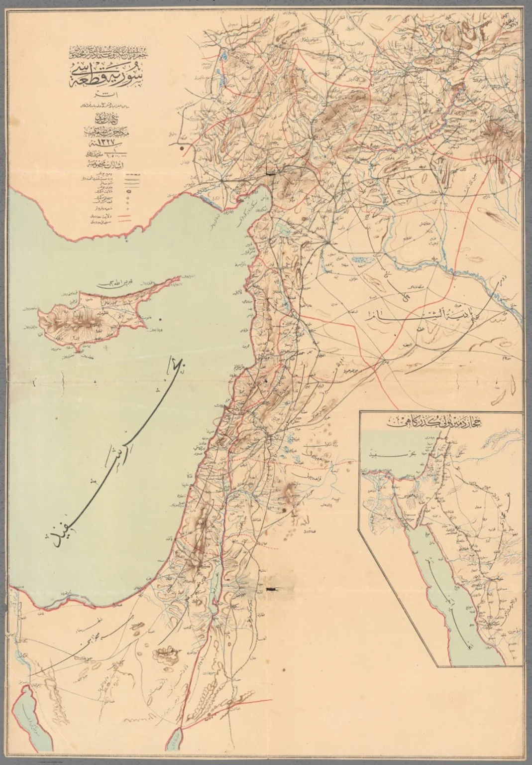
1911, he Route of the Hejaz Railway, Osman Nuri, fig. 3
Osman Nuri, was a senior Ottoman Army Cartographer who worked for the military office. The Maps featured here (in 1909), were classified and used for strategic purposes by other Senior Officers. The Balkan Map in fig.2 was made just before the the Balkan Wars (1912-13), when the region was swallowed by nationalist sentiment and greatly influenced the fall of the Ottoman Empire. Additionally, the maps in this collection capture the angst and tension leading to World War I (1914-1918); Making this map not only extremely rare (since it was never sold publicly or distributed), but a a piece of history that encapsulates the strategies and viewpoints of Military leaders during a time of internal national turmoil.
Beginning 1903, the Ottoman regime invested immense treasure and manpower to build the Baghdad Railway through southern Anatolia (which was to run from Istanbul to Baghdad, although it was not completed until 1940!). The Hejaz Railway, built between 1900 and 1908, connected Damascus to the holy city of Medina (leaving Hajj pilgrims with only a relatively short final leg to Mecca). In 1909, presaging the Armenian Genocide (1915-23), Turkish mobs, supported by the authorities, killed over 20,000 Armenians in what became known as the Adana Massacre. The present map would also have been in use during World War I, when the Levant became a major theatre of conflict.
Nuri’s cartographical style is known for only displaying absolutely vital information over clutter and embellishments. He prioritized primary features of the land, industrial feats, and key religious sites for the Abrahamic religions; ensuring that these maps presented a “neutral” and accessible view of the region for military operations. This approach to cartography cemented Osman’s maps as guides for key events during that time (and well after WWII even), below is a quote from the notes of fig. 3:

The Scientific Form of the Sphere& Earth by Abdurrahim Hilmi Bey, fig. 4
Mapping the Heavens and Time
Our current orientation of the Night’s sky is still influenced by the work of cartographers from the Ottoman Era. From Al-Asad (the Lion, or Leo Constellation), An-Nisr al-Waqi (the Falling Eagle, or Vega Star in Lyra Constellation), even the popular Fomalhaut derives its linguistic origins from Fum al-Hut, meaning the Mouth of the Whale. But why has the Ottomans celestial influence on the sky lasted so long?

Abdurrahim Hilmi Bey's Histomap of World History illustrated using rivers, fig. 5
If Ottoman explorers wanted to traverse the seas or expand their territories they had to chart the sky above them and the world around them. The Istanbul Observatory became the canvas for their mapmaking and development of the Astronomical sciences where they created everything from Celestial Clocks, Armillary spheres, and early telescopes or “Sighting Tubes”. The Observatory was founded by Ottoman scientist and astronomer, Taqi al-Din, in 1577. It’s no wonder that Ottomans orientation of the Night Sky has persisted through the ages, their attention to precise measurements and cycles could mean the difference between life or death and is an extension of their deepened relationship with their land. Sometimes dissatisfaction with present day standards leads to achievements that outlive the inventor.
Abdurrahim Hilmi Bey was a geographer and cartographer who, from my research, was interested in everything from plant classification to casting charts of the stars. He is a perfect example of a Cartographer who entered the profession in the traditional Ottoman nature – Survival balanced by Imagination. The extent of what I’ve found on his personal life is the following:
According to the attached note, the collection was allegedly connected with the family of the Turkish writer Ahmed Cemil Akıncı (1914-1984). His father and a possible author, Abdürrahim Hilmi Bey (Sipahizâde) was of Sipahi origins from Rumelia and was educated at the Fatih Madrasa in Istanbul. Hilmi Bey was in charge for the railway and education in Egypt, Palestine, Syria and Hejaz, where he spent a large part of his life. This would explain the author’s unattachment to Istanbul and Turkey.
Hilmi Bey’s maps showcase mastery of the Ottoman’s Astronomical technology. Expertly blending both Turkish and Greek correspondences with Constellations and Zodiacs. Through archival documents we learn more about Abdurrahim’s commitment to classification. With texts ranging from dissecting the soil beneath his feet, to global maps of the worlds’s nations, to documents that featured photos of Turkish coins organized side by side. It’s not a stretch to see that Hilmi Bey wanted to create an archive of everything from the granular to the grandiose qualities of his world. Among my favorite is his Histomap documenting the History of Rivers.
Histomaps are detailed data visualizations that chronicle specific theme’s changes across time. For example, there are Histomaps that chart the evolution of Abrahamic religions, World Civilizations, Agriculture, etc. (these were likely Hilmi Bey’s inspiration). They serve as a visual aid for relating to large scopes of Human feats. Fig. 5 is a time chart in Arabic that depicts the History of Rivers from the times of antiquity to the early 20th century.
The largest collection of Abdurrahim Hilmi Bey’s work was published in 1918 during the final moments of World War I, I suspect that the pieces featured therein were accumulated during and before WWI but perhaps weren’t able to be published due to the conflict.
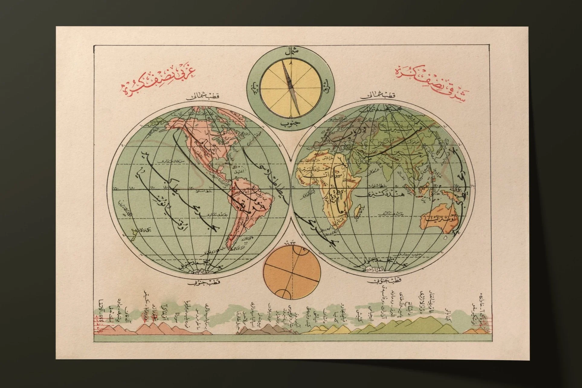
[1927 Double Hemisphere Atlas Map with comparative illustrations of the heights of Mountains and Volcanoes, Ikbal Kutuphanesi Sahibi Huseyin, fig. 6]
Remapping the World

Turkey 1927, Ikbal Kutuphanesi Sahibi Huseyin, fig. 7
The work of Ikbal Kutuphanesi Sahibi Hüseyin as geographer and cartographer allows us a peak into what the field was like following World War I. Many of his archived works were published in Turkey a few years after the dismemberment of the Ottoman Empire in 1927, so it seems that he was part of the cartographers in Istanbul who were drafting maps with their new Turkish boundaries. World World I shifted many borders so this era of remapping and reshaping highlights the importance of cartographers after War Time.
The pieces featured here are from Huseyin’s 1927 collection titled “New School Atlas” published in Istanbul. Huseyin’s style is informative, colorful, and features beautiful calligraphy; perhaps a reflection of the combination of hope for the new future, and grief of the collapsed empire he was raised in. Or maybe it begins and ends with him simply doing his job and wanting to create something legible. Either way, Ikbal’s work provides a visual relief for someone like me, an American whose initial interactions with maps were that of a Western Nature. These Ottoman Era cartographies disrupt the American social narrative that mapmaking was cemented by Europeans like Columbus or those seeking to chart routes during the Trans-Atlantic Slave Trade. It’s sobering to not only see these maps of Turkish territories, but to also see their maps of the globe, marked by Arabic Calligraphy. It’s the sort of visual variation that expands world views and possibilities.
Cartography serves as a reliable tool of wayfinding that breathes across time. Decades after their creation they tell us a lot about the persistent characteristics of the region as well as aiding our understanding of the unique conditions of the time they were conjured in. These footprints of discovery and truth allow us to orient ourselves today, whether with the intention of building on their work, or deciding to abandon it altogether.
Each map featured here is available for print of high-quality paper, HERE.
You’ll also find a host of other ancient maps, archival documents, and tools for Earth Stewards.
____________________
Bibliography
https://www.hurriyetdailynews.com/cartography-in-ottoman-times-11437
The True Stars of Cartography: Ottoman Mapmakers